


The Flood Zone
 What is this flood zone everybody is talking about?
Flood zones are geographic areas that the FEMA has defined according to varying levels of flood risk. These zones are depicted on a community's Flood Insurance Rate Map (FIRM) or Flood Hazard Boundary Map. Each zone reflects the severity or type of flooding in the area.
This does not necessarily mean that in a zone where the flood risk is highest you automatically pay the highest insurance premium. It also depends on the property itself which you are looking to buy. You will pay more if it is a 40 year old home that was built on a 6' elevation which was mandatory back in the days. However, if you are constructing a new home and necessary fill dirt will bring the elevation up to 9.5' for example in the same neighborhood, your insurance premium will most likely be less for a comparable size of home.
If you buy or build a house cash, it is at your sole discretion whether you want to pay for flood insurance. If you are using domestic financing the bank will definitely make a flood insurance mandatory.
Definitions:
-
Base Flood Elevation (BFE): The computed elevation to which floodwater is anticipated to rise during the base flood. Base Flood Elevations (BFEs) are shown on Flood Insurance Rate Maps (FIRMs) and on the flood profiles. The BFE is the regulatory requirement for the elevation or floodproofing of structures. The relationship between the BFE and a structure's elevation determines the flood insurance premium.
- Flood Insurance Rate Map (FIRM): The official map of a community on which FEMA has delineated both the special hazard areas and the risk premium zones applicable to the community.
-
Federal Emergency Management Agency (FEMA): The federal agency under which the National Flood Insurance Program (NFIP) is administered. In March 2003, FEMA became part of the newly created U.S. Department of Homeland Security.
- National Flood Insurance Program (NFIP): The program of flood insurance coverage and floodplain management administered under the Act and applicable Federal regulations promulgated in Title 44 of the Code of Federal Regulations, Subchapter B
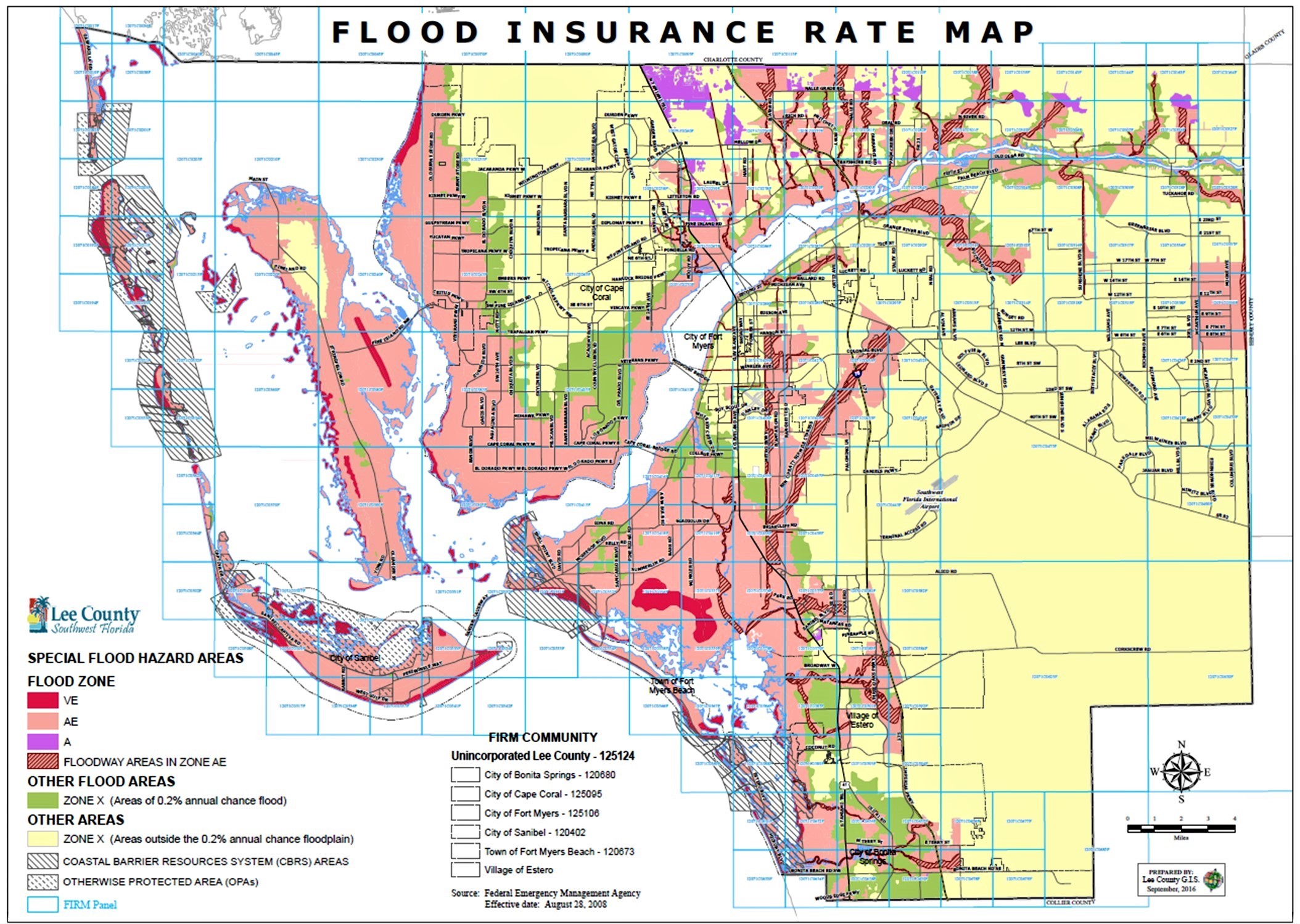
FEMA Flood Zone Designations
Moderate to Low Risk Areas
|
ZONE |
DESCRIPTION |
|
*2PACFH also known as X (shaded) |
Areas of 0.2% annual chance flood; areas of 1% annual chance flood with average depths of less than 1 foot or with drainage areas less than 1 square mile; and areas protected by levees from 1% annual chance flood. *X (shaded) is also known as the 0.2% Annual Chance Flood Hazard.
|
|
X (unshaded) |
Areas determined to be outside the 0.2% annual chance floodplain. |
High Risk Areas
|
ZONE |
DESCRIPTION |
|
A |
The 1% annual flood (lOO-year flood), also known as the base flood, is the flood that has a 1% chance of being equaled or exceeded in any given year. The Special Flood Hazard Area is the area subject to flooding by the 1% annual chance flood. The Base Flood Elevation is the water-surface elevation of the 1% annual chance flood. No Base Flood Elevations determined. Because detailed analyses are not performed for such areas; no depths or base flood elevations are shown within these zones. |
|
AE |
The 1% annual flood (lOO-year flood), also known as the base flood, is the flood that has a 1% chance of being equaled or exceeded in any given year. The Special Flood Hazard Area is the area subject to flooding by the 1% annual chance flood. The Base Flood Elevation is the water-surface elevation of the 1% annual chance flood. The base floodplain where base flood elevations are provided. |
High Risk - Coastal Areas
|
ZONE |
DESCRIPTION |
|
VE |
Coastal areas with a 1% or greater chance of flooding and an additional hazard associated with storm waves. These areas have a 26% chance of flooding over the life of a 30-year mortgage. Base flood elevations derived from detailed analyses are shown at selected intervals within these zones. Coastal flood zone with velocity hazard (wave action); Base Flood Elevations determined. |
Federally backed mortgages require flood insurance for those properties having structures located in an A, AE, or VE zone.
How can I find out, in which flood zone my property is located?
On the FEMA Website you can enter your address and get detailed information about your flood zone. In order to receive a flood insurance quote please contact your insurance agent.
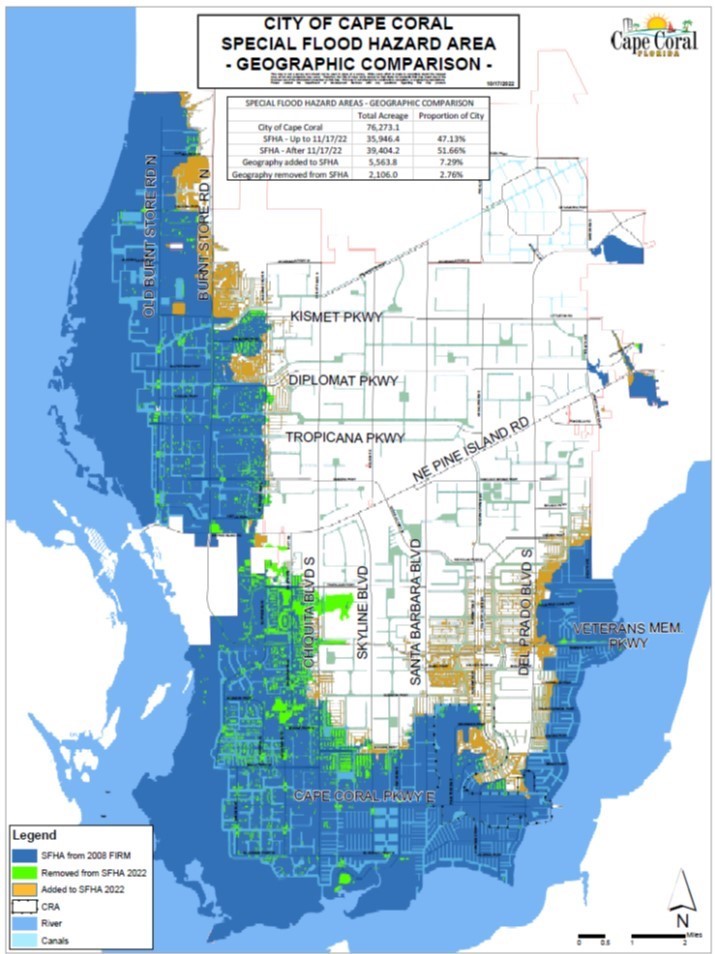
This is a general overview of the special flood hazard areas in Cape Coral: